Outline of the North-Eastern Petra Project
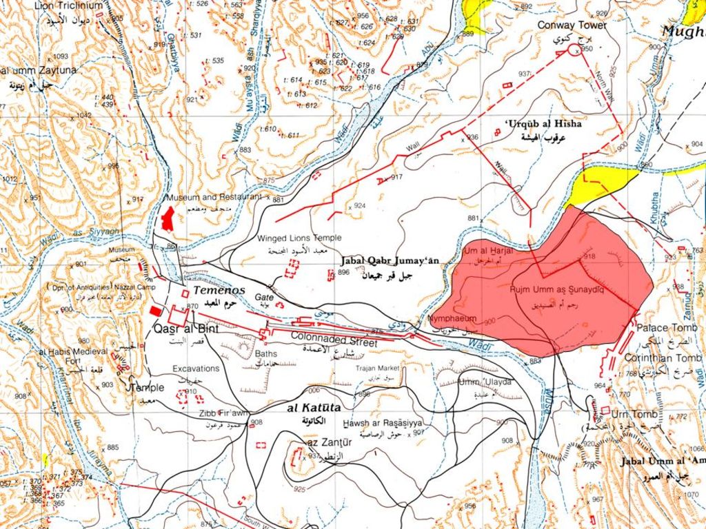
The North-East Petra Project (NEPP) intends to conduct an intensive surveying, mapping and documenting in the area of NE Petra (site marked as „Rujm Umm al-Sunaydiq“), being roughly the quarter of the city center between the Wadi Mattaha, the Wadi Musa and the Palace Tomb (figs. 1–6). The ruined structures located there have, so far, been neither very extensively described nor fully and scientifically documented. The planned activities of NEPP include in a first step:
- description, measuring and photographing of the ruined complex;
- documentation of the complex using the advanced, electronic methods in order to provide a reliable map of the area.
The NEPP site – apparently consisting of several large ruined architectural complexes – is located directly NE of the confluence of the Wadi Mattaha and Wadi Musa drainages, on the high hill overlooking the eastern end of the Colonnaded Street, and west of the Palace Tomb in Petra (figs. 1–3). The site is ca 250 m (E-W) x 150 m (N-S). Its northern extremity is occupied by Umm al-Harjal and the eastern one by Rujm Umm al-Sunaydiq, the latter seemingly being the name of the entire area. It is apparent that the site contains several buildings as well as some surprisingly „empty“ spaces.
Despite the existence of imposing and extensive ruined architectural structures at the site, neither an exhaustive description nor proper surveying and mapping has been conducted there, as has been stated on previous occasions (e. g., Wenning 1987: 245–246).

Although this is one of the largest very densely occupied spaces within the city center, which significantly included several monumental buildings, Brünnow and von Domaszewski, the early explorers of Petra in the early 20th century, report only briefly and without any further commentary the discovery of a statue and some „ruins“ featuring few wall lines (Brünnow & Domaszewski 1904: 318–319 nos. 412–415). Alois Musil indicates several buildings on his map of the Petra city center (Musil 1907, following p. 343) but these are very schematic sketches and, anyway, Musil does not discuss any of these structures in detail. Gustaf Dalman devoted an entire chapter to the area „under el-hubta“ but his observations concentrate exclusively on rock-cut structures, and no mention whatsoever of the clearly visible ruins located further west was made (Dalman 1908: 314–329). The most concise indications come – once again – from the „Deutsch-türkisches Denkmalschutzkommando“, the early 20th century German-Turkish project, which noted the existence of several buildings above a structure they interpreted to be a small theater. However, the German scholars pointed on the existence of a large, monumental „room“ of ca 30 m length (Bachmann and Wantzinger and Wiegand 1921: 32–33).

It is most surprising that all relevant, modern maps of the Petra’s center feature almost no extant structures or ruins in this area despite that fact that these are clearly visible and quite important in appearance. This fact is not only puzzling but, in fact, most detrimental for the Petra’s future. The area which the NEPP requests to investigate witnesses almost no tourist activities despite its apparent interest. Most visitors to Petra do not even attempt to venture up to the Palace Tomb and the few who do so either go again down towards the Wadi Musa, proceed along the monumental tomb facades toward the Tomb of Sextius Florentinus, or simply climb up to Jabal al-Khubta. Virtually nobody visits the area under the NEPP consideration, if it is not for trespassing in order to reach the Petra church on the other side of Wadi Mattaha, connected to the NEPP area by a small modern bridge.
It is apparently incompatible with the recent increased interest in Petra and with all cultural resource management activities which have affected the site in the last decades that one of apparently most significant areas of Petra, clearly notable for its outstanding ruins, remains neither carefully documented nor archaeologically explored. The NEPP attempts to redress this omission by conducting a comprehensive program of scientific exploration of the area. There are two compelling reasons for conducting this activity.
At first, it is clear that while the site, at this point of time, bears significant monumental appearance, it also continues to deteriorate. Large-scale stone collapses are visible everywhere and some apparently could have happened only recently. Architectural elements continually shift in place and their original location may soon be lost. The stone architecture at the site is monumental in character but even such does deteriorate with time. Therefore, it is with great urgency that the NEPP requests the permission to carry out the necessary documentation of the site.
It further seems important to us that this project is conducted under the auspices of the Department of Antiquities and by people specialized in the archaeology of Petra in order to produce a maximum of valuable information.