The International Umm al-Biyara Project

Preliminary Report on the 2011 Season

by Stephan G. Schmid and Piotr Bienkowski

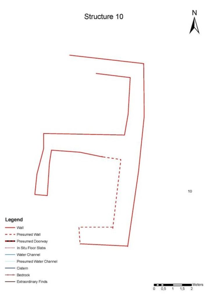
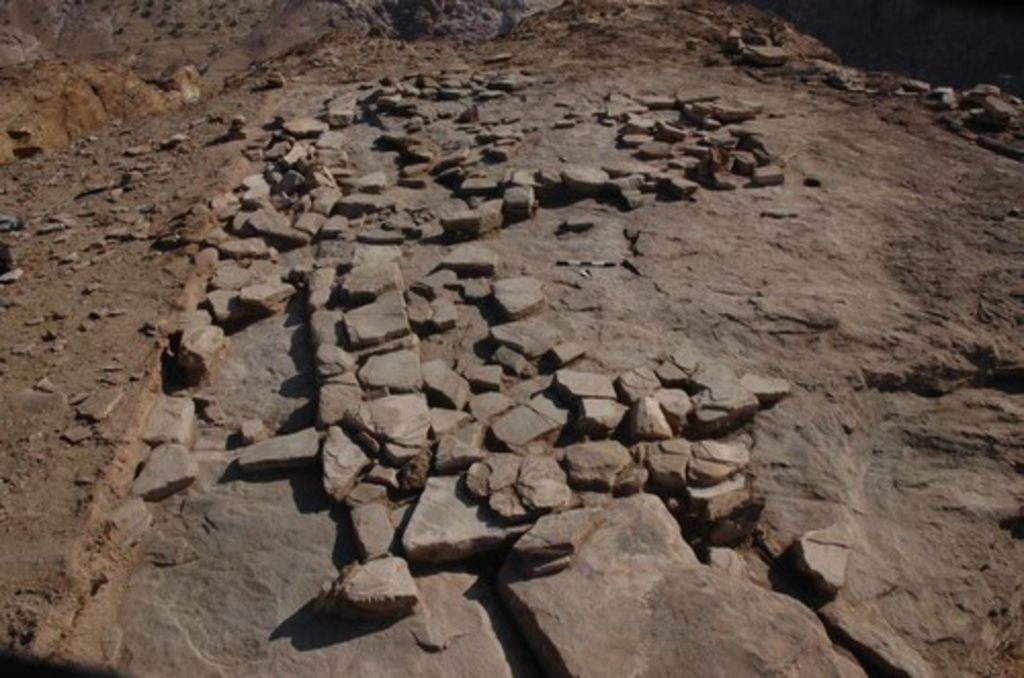
III. 2011 excavations – a. structure 10

Following the results of the 2010 survey, three main areas were selected for excavation activities during the 2011 season, Structure 10 (ST 10 on fig. 2) near the SW angle of the plateau, Structure 26 (ST 26 on fig. 2), built at the very edge of a promontory protruding towards East and the city centre, and Structure 20 (ST 20 on fig. 2) standing on the NE edge of the plateau.

Structure 10 (ST 10 on fig. 2, figs. 3. 4) is situated on the western half of the plateau, more or less on its SW angle. Its exposed situation on an outcropping rocky promontory, as well as its rectangular, almost square plan according to the surface survey (fig. 3), let to the hypothesis of a watchtower. This would have well fit with its apparently carefully chosen position. The structure stands at a point with a perfect view all around the area, and especially towards all the springs supplying the long distance water supply of Petra: from ‘Aïn Tibitbi in the Baydha area to ‘Aïn Braq on the road to Taybeh, including ‘Aïn Mousa and the ancient settlement of el-Gji (Gaïa). The view from that spot is even more extensive, including the prominent hill of Dilagha at the very SE, itself occupied by a huge watchtower and giving access to the track leading to Gharandal, Jabal Haroun to the SW and the Wadi Araba to the W as well as Jabal Qaroun to the N. From some spots on the NW tip of Umm al-Biyara one can even see Qasr Umm Rattam, a major guard post controlling the access to the region around Petra from Wadi Araba on Umm Rattam and its strategic importance see Lindner et al. 2007; Lindner et al. 2000. .

Fig. 3: Groundplan of ST 10 before excavation (plan: G. Teltsch and W. Kennedy)

During the 2011 season of IUBP it quickly turned out that whatever building was standing at the spot of ST 10, it was almost completely dismantled and the stones robbed out and taken away from their original context (fig. 4). At the end, what remained was a rather clear N–S wall and a possible right angle to it at the S end. The walls – or rather the foundation of walls – are built of flat stones, similar in appearance to fragments of floor slabs. This is typically the material that can be obtained by quarrying on the plateau of Umm al-Biyara, where we recorded in 2010 an entire area of manifest quarrying activities (ST 23 on fig. 2). Although the architectural remains of ST 10 do not allow a more precise definition of its function, the pottery from the excavated areas rather clearly indicates a quite precise chronology. Already during the 2010 survey it became clear that ST 10, although in the immediate neighbourhood of the Edomite settlement excavated by Crystal-M. Bennett, provided an overwhelming majority of Nabataean pottery. Interestingly, this picture not only was confirmed during the 2011 excavation, but the chronological frame of the Nabataean pottery could be more precisely defined. With exception of the pottery from the first level, all the other levels showed homogeneous Nabataean pottery of phases 2b and 2c after Schmid 2000. and, therefore, can be dated to the fourth quarter of the 1st century BC and the first quarter of the 1st c. CE respectively.

Fig. 4: ST 10 after excavation, view from N (photo: S. G. Schmid)

In conclusion, ST 10 indicates that the Nabataeans had occupied the plateau of Umm al-Biyara at the latest during the last quarter of the 1st century BC with buildings in most parts. Although the architectural remains from the eastern fringe of the plateau that were partially excavated in 2011 see below. were built in the later 1st c. CE, the surface pottery from these parts also showed quite a lot of earlier sherds belonging to the second half of the 1st century BC. This, together with the results from ST 10 would indicate a complete covering of the plateau by Nabataean buildings during the reigns of Obodas III and Aretas IV.